
Sunday, March 8, 2015
Circling the Southern Half of the Chesapeake Bay Roadtrip - March 2015
For a three day weekend, I decided to look for an area nearby that I have not explored very much. After looking at a map, I decided to do a roadtrip that included driving across the mouth of the Chesapeake Bay. The roadtrip has a nice range of variety from historical sites, beaches, wildlife, and nightlife and restaurants. A nice trip for everyone. I also wanted to bring the dog, and found this roadtrip to meet my Fido Approval standards. Happy travels!
Sunday, August 17, 2014
Yakima to Bend & The Ellensburg Rodeo - August 2014
Later this summer, I'll be flying west to explore the eastern side of the Cascade Range. I'll begin in the Yakima Valley, known for their produce, hops, and wineries. From there we will be heading south. Our destination will be Bend, Oregon, which averages 300 days of sunshine a years. Perfect for the outdoor lover. Bend, Oregon also has an abundance of Breweries. Sunshine, beer, and the outdoors. Sounds amazing. After our share of beer, we'll venture to Tumalo Falls and the Cascade Lakes Scenic Byway. The byway will pass between the Three Sisters and Mt. Bachelor volcanoes and by many small and beautiful lakes. After our journey is complete in Bend, Oregon, we'll have a stopover at the Full Sail Brewery in Hood River, and over to Cascade Locks, Oregon to hike up the Eagle Creek Trail. It's supposed to be spectacular. We'll finish off our trip in Ellensburg, Washington for one of the largest Rodeos in the United States.
This area of the Pacific Northwest I feel does not get enough attention as a travel destination. Seattle, Portland, Mt. Rainier, Olympic NP and the pacific coast are all marvelous trips in their own, but I felt it was time to create a map that highlights the other wonderful side of Washington and Oregon. I look forward to my adventure, and I hope others find great use out of this map as well. Happy Travels!

This area of the Pacific Northwest I feel does not get enough attention as a travel destination. Seattle, Portland, Mt. Rainier, Olympic NP and the pacific coast are all marvelous trips in their own, but I felt it was time to create a map that highlights the other wonderful side of Washington and Oregon. I look forward to my adventure, and I hope others find great use out of this map as well. Happy Travels!
Sunday, August 4, 2013
Salt Lake City to Yellowstone National Park - August 2013
In a few weeks, I'll be heading out west for a road trip starting in Salt Lake City and ending in Yellowstone National Park. Just prior to my arrival, I'll have a coworker also traveling to Yellowstone. It's been a year since my last post, and thought this would be a perfect opportunity to create my latest Maps For Friends post. In this post, I cover a lot of area and kept it to the important basics. I left off hotel costs, and descriptions, but made sure to include mileage and highlights. I look forward to visiting the United States first and most famous National Park.


Tuesday, August 21, 2012
Colorado and Utah Summer Roadtrip - August 2012
At the end of last year, there was a commercial http://www.youtube.com/watch?v=VE4bcq8Plzk that aired many many times. Every time it was on I loved it, and every time I said to myself "I'm gonna go find that place". So, I made it a new years resolution for 2012. Back in March, great airfare prices popped up for Denver, I purchased the airfare and now here I am. I'll be traveling with a couple friends throughout Colorado and Utah, and fulfill my New Years resolution and go photograph the Corkscrew at Fisher Towers in Utah and visit many great places along the way. I made this map for my roadtrip companions and I, but hope other friends will find the map below useful as well:


Friday, July 20, 2012
Shenandoah National Park Guide to the Central District - July 2012
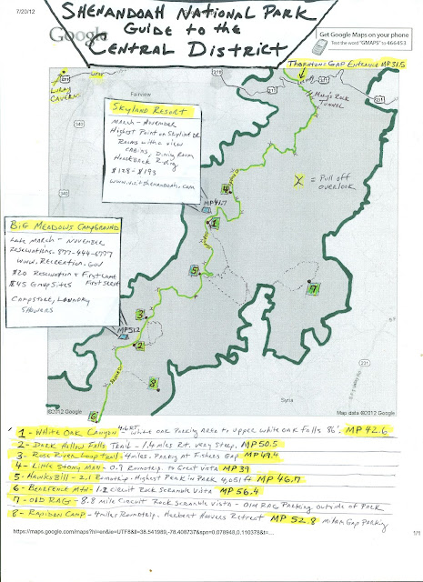
I recently went camping at Big Meadows, and I am planning another camping trip with a group of friends to the Central District again very soon. I've done a lot of hiking in this area of the park, and find it to be the most compacted with very rewarding and popular hikes. I thought I'd make a map to provide a better visual of distance and layout of the central district of Shenandoah National Park to others. I've included waterfall hikes, and vista hikes, along with two areas for overnight lodging. Along with the details, I've included the Mile Posts where each trail starts, as well as where the car pull off overlooks are located. Below is the helpful map for friends I created.

Thursday, May 17, 2012
U.S. Route 15 Weekend Getaway Guide - May 2012
I've always loved driving along route 15. I've been to Cunningham Falls a few times, hiked a vista in Catoctin Mountain Park, driven through the Gettysburg Battlefield, and I have many wonderful childhood memories of Cozy Restaurant. I guess in other words, this area of MD/PA is a special place to me. I've recently recommended a few of these places to friends, and after a recent drive up route 15, I realized it is time I create a Map for Friends. I've included a number of places on the map, but intentionally left off a secret location. Camp David. I know it's location is no longer secret, but I'll pretend it is on this map. Instead, everyone should check out the Camp David Museum located in the Cozy Restaurant! and on to the map. Enjoy!


Saturday, March 24, 2012
Olympic National Park, "Twilight" & "The Goonies" Movie Location Guide - March 2012
I have a coworker planning a trip to the Pacific Northwest and he asked me about Olympic National Park. Having been there, I shared a few stories, described the area, and happened to mention "Twilight" being filmed there. He quickly responded he'd rather look for "The Goonies" location. After the conversation I decided I wanted to make a map of the area that included the highlights of Olympic National Park, as well as a location guide for both movies. Below is the map I made for him.


Subscribe to:
Comments (Atom)